
The 2022 NSW Vegetation Clearing Report reports on statewide clearing and clearing of land regulated by the Local Land Service Act 2013 (LLS Act). Woody vegetation clearing is reported between 2009 and 2022 across the state. Since 2018 woody vegetation clearing data has been combined with non woody vegetation clearing data to give total clearing for the state and Category 2 regulated land. Category 2 regulated land is land subject to Part 5A of the LLS Act, which commenced in August 2017.
Vegetation clearing is captured by the Statewide Land and Tree Study. See the 'How vegetation clearing is reported' section on this webpage for further information.
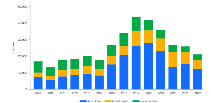
Native woody vegetation clearing statewide between 2009 and 2022
Native woody vegetation clearing (excluding plantations) between 2009 and 2022 is represented in Figure 1. Results for 2022 show that 21,131 hectares of native woody vegetation (excluding plantations) was cleared statewide. This is a 21% decrease when compared with 2021. This includes landcover classes: agriculture, infrastructure and native forestry. Further information on landcover classes is available in the 'How vegetation clearing is reported' section on this webpage.
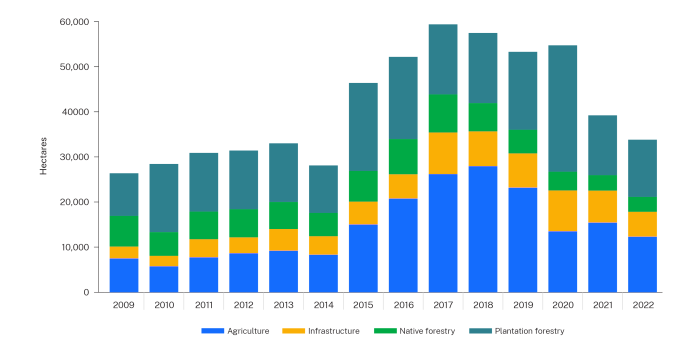
The Statewide Land and Tree Study has been reporting on change in woody vegetation (including plantations) since 2006. Figure 2 shows all woody vegetation clearing between 2009 and 2022 for the landcover classes of agriculture, infrastructure, native forestry and plantation forestry.
Information on woody vegetation clearing statewide and across all landcover classes between 2009 and 2022 is accessible on our new Statewide Land and Tree Study (SLATS) Insights Dashboard. The interactive dashboard presents clearing trends and insights through time, and by region across New South Wales.
Explore the new SLATS Insights Dashboard
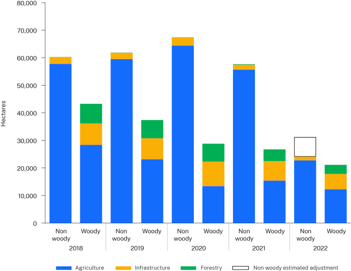
Native woody and non woody vegetation clearing statewide from 2018 to 2022
Analysis of land clearing from 2018 to 2022 includes both woody and non woody vegetation clearing (Figure 3).
Agricultural clearing of 12,283 hectares contributed 58% to all native woody vegetation clearing in 2022. Agricultural native woody vegetation clearing decreased by 20% when compared to 2021. In 2022 infrastructure (26% of all native woody clearing) and native forestry activities (16% of all native woody clearing) both decreased by 22%.
Native non woody vegetation clearing confirmed in 2022 is 24,121 hectares. We estimate an adjustment of approximately 6,000 hectares of additional clearing will be confirmed next year. See 'Notes on the non woody method' section for more information. Including the 6,000 hectares estimated adjustment, 2022 had a 48% decrease to native non woody vegetation clearing when compared to 2021. Annually, agriculture has accounted for over 90% of all non woody vegetation clearing since 2018.
Notes on the non woody method
Non woody clearing can be more difficult to detect than woody clearing because full conversion of undisturbed ground cover to exotic pastures or cropping can take more than 12 months. Most non woody vegetation clearing can be confidently attributed when the clearing occurs. Some areas of disturbance may be flagged for confirmation of clearing in the following mapping year.
For 2022 statewide, an estimated 6,000 hectares has been added to account for clearing that will be confirmed in the 2023 report. This estimated adjustment allows for comparison of 2022 non woody vegetation clearing against previous years. The estimated adjustment is created by using the percent of total adjustments against total clearing in the last 4 years, and applying it to the 2022 confirmed clearing. This figure is then rounded to the nearest thousand hectares.
The 2022 estimated adjustment for Category 2 regulated land is 5,000 hectares.
Figures 3 and 4 represent non woody clearing confirmed for 2021 and include the estimated adjustment for 2022. This estimate is represented as an outline in the figures.
A non woody estimated adjustment has not been added to figures on clearing allocation (Figures 5–8). The final non woody figures for 2022 will be published with the 2023 report.
All NSW vegetation clearing data within this report is available.